A Vendre Belle Propriété...
NEW YORK ; CASTORLAND ; COLINET Victor (1840.)
£6000.00
Please contact us in advance if you would like to view this book at our Curzon Street shop.
THE REMNANTS OF A SETTLER COLONY IN NEW YORK
Lithographed broadside with original hand-colour, on a sheet of fine laid paper bearing a ‘bunch of grapes’ watermark. Measuring 615 by 455mm. A fine copy untrimmed with some soft old folds and a few light spots. Paris, Lith. de Delarue, c.1830 -
Very rare: an apparently unrecorded large-format broadside concerning Castorland, a French settler colony in Upstate New York.
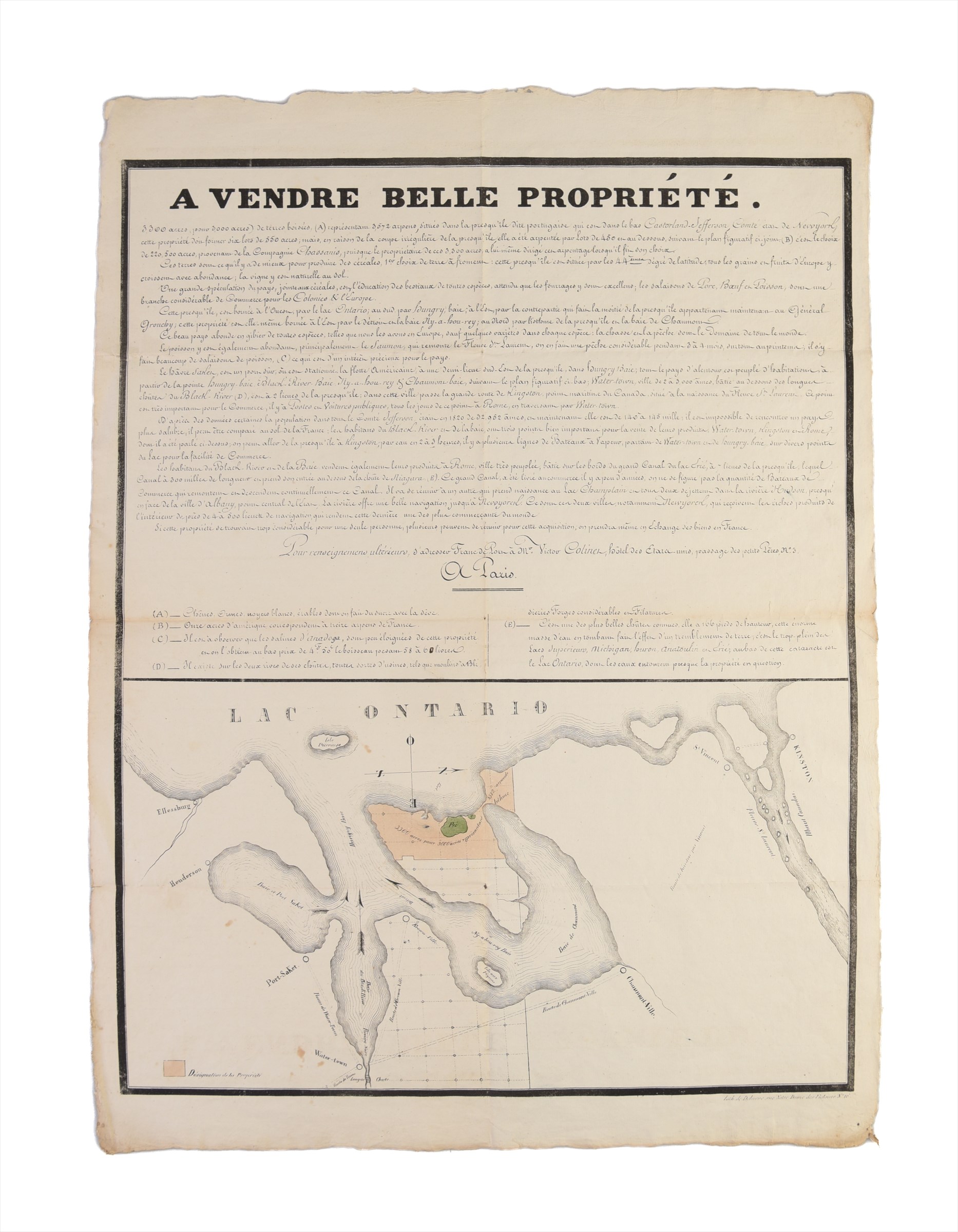
It was published in Paris for Victor Colinet, the former quartermaster of Castorland, to promote the sale of a large land tract along Lake Ontario that was once part of the colony. The promotional text includes much intriguing intelligence, as well as an overly optimistic depiction of the region’s agrarian potential. Importantly, it is illustrated with an attractive original map of the Chaumont Bay region highlighting the real estate in question.
In the wake of the Revolutionary War, the State of New York was in a perilous financial position. By settling the Upstate region, it sought to both fortify its Canadian border and encourage trade and tax revenue. The investment required for such an undertaking was beyond the scope of New York State and so private investment was sought. Alexander Macomb (1748-1831), an American fur trader and merchant, purchased a huge tract of land (nearly four million acres) extending from the shores of Lake Ontario and the St. Lawrence River to the Adirondacks at a price of 8 pence (New York currency) per acre. Even at that low price, Macomb soon realised that he was unable to attract enough settlers to recoup his outlay. As such, in 1792 he sold a large portion of the land (at 20 pence per acre) to William Constable, an American based in London. Constable worked closely with Gouverneur Morris, the energetic American Ambassador to France.
Of course, the idea of populating the land with French settlers was appealing to both nations. The French were allies during the Revolutionary War and, in the wake of their own Revolution, many nobleman and other affluent French were compelled to leave France. Led by businessman Pierre de Chassanis, the interested parties prompted established the Compagnie de New York, which purchased 210,000-acre (850 sq km) tract from William Constable, for the price of 50 cents per acre.
The settlement, Casatorland ("Land of the Beaver") occupied an irregular triangular tract that extended from Chaumont Bay (named after Jacques-Donatien Le Ray de Chaumont), on Lake Ontario, into the interior to points deep within the ‘Great Wilderness’ of the Adirondack Foothills, following the north bank of the Black River (so taking in pieces of the modern counties of Jefferson, Lewis, and Herkimer). However, the prospectus misrepresented the climate, the arability of the land, and the navigability of the river. Over the following three years, affluent settlers struggled in difficult conditions and, by 1800, the settlement was abandoned.
While the land remained under the control of the Compagnie de New York until its dissolution in 1814, landholders and investors retained title to their plots afterwards. This included Victor Colinet. His lot occupied the extreme western corner of the colony (on the Point Peninsula) that guarded the mouth of Chaumont Bay, Lake Ontario. The forested property, which could conceivably be cleared for farms, was potentially ideal for provisioning the area’s growing settlements, such as Watertown. This broadside advertises that land for sale.
The map includes the entire northwest corner of Jefferson County, New York, centred upon the Point Peninsula (referred to in the text as the "presqu'île portu-gaise"), of which its western half features the real estate in question. The great expanse of Lake Ontario appears in the upper part, with Chaumont Bay and its various inlets depicted with arrows showing the direction of currents. The map notes the towns of Port-SaKet (Sackets Harbor); Water-town, located at the mouth the Rivière noire, (Black River), shown with its cataracts which generated power for the town’s mills; and Chaumont-Ville; while the map delineates numerous roads. In the upper right is the mouth of the Fleuve St. Laurent (St. Lawrence River) which marks the border with Haut Canada (Upper Canada), noting the major city of Kinston (Kingston, Ontario).
The portion for sale was roughly 3,300 acres divided into 550 lots. The text describes the good commercial, postal, and communication links in the area; it then dubiously states that the land was ideal for growing cereals and fruit; and erroneously claims that Sackets Harbor was still a station of the American Navy (it has ceased to be after 1815).
This is a valuable record of a short-lived colony, the history of New York, and American concerns in the aftermath of the Revolutionary War.
Cf. Desjardins, S., & Pharoux, P., Castorland Journal: An Account of the Exploration and Settlement by French Emigres in the Years 1793 to 1797 (Ithaca, 2010); Le Fahler, C., Castorland, une colonisation française dans l'État de New York, in La France et les Amériques entre révolutions et nations: 1776-1871 (Rennes, 2021); Pilcher, E., French Refugees in the Western Adirondacks, 1793 – 1814 (Ithaca, 1985); Webster, C.J., "French Emigres in the Wilderness" in New York State Tradition, vol. 17, no. 2 (Spring 1963), pp. 43-47.
Stock Code: 249538


