Arabia.
ARABIAN PENINSULA. ; U.S. ARMY AIR FORCE (1944.)
£1000.00
Please contact us in advance if you would like to view this book at our Curzon Street shop.
'RESTRICTED'
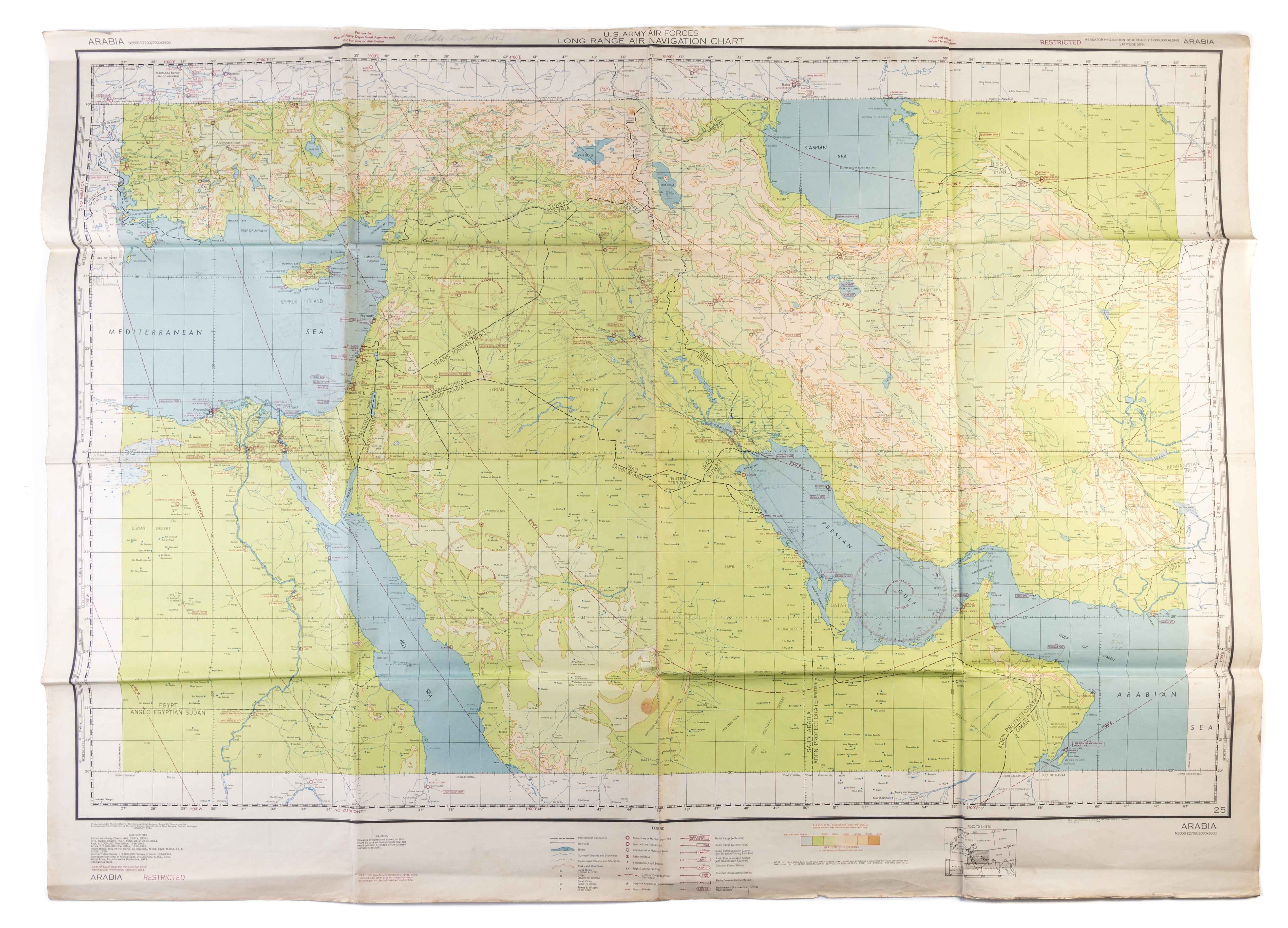
Second edition, subject to correction. Large long range navigation cart, coloured. Scale 1:3,000,000. Verso containing 3 aerial views of the islands of Bahrein, Cyprus and Rhodes (scale 1:97,500) alongside 10 smaller sectional views capturing features of their coastlines. Several ms. notes in pencil, a few small marginal tears, one light stain, otherwise good. Washington, D.C., Army Map Service, U.S. Army,
The second edition of this impressive chart, issued for use by the U.S. Army Air Force during the Second World War. The first edition was published two years earlier, in April 1942. This example features manuscript notes, made by a pilot navigating the Eastern Mediterranean, Syrian Desert and Persian Gulf.
The chart covers a vast geographical area: west past the Suez Canal in Egypt; north as far as the Iranian/USSR boarder on the Caspian Sea and East beyond the Iranian/Afghanistan boarder, encompassing the whole of the Arabian Peninsula and Persian Gulf. Marked "Restricted" for the use of U.S. officers, the chart was produced "for use in day light" with the warning that due to wartime conditions "lights, radio facilities, and other aids to navigation may be changed or discontinued without notice."
Throughout the Second World War, rapid technological advancement - including the use of jet engines - meant that planes were able to travel ever-greater distances as single journeys. Alongside this, the development of radio technology began to allow pilots to fly in a wider range of weather conditions. This development was of particular relevance in the Middle East where, alongside sandstorms, US troops deployed as part of the Persian Gulf Command noted that those, "… who arrived in theatre in the summer of 1942 were welcomed by torrential rains and mud more than a foot deep."
Originally from a neutral standing, the US were assisting the allied war effort by supplying military equipment to both The British and Russians. However, shipping via main Atlantic ‘northern’ route was perilous with convoys coming under repeated and aggressive attacks by Nazi U-boats.
Seeking an alternative, the Allies realised that the only other option was a ‘Southern route’ through the Persian Gulf. The naval journey terminated in Iran which became the starting point of the ‘Persian Corridor,’ a monumental land route that used convoys and trains through Iran to deliver equipment to the Russian army.
Originally headquartered in Baghdad, The Iranian Mission – which had been created by Roosevelt in 1941 – was moved to Basra in March 1942. This chart being printed just a month later, must have been in preparation for this move and giving the US crucial up to date information in this area of interest. The United States “…rapidly became the leading producer of flight charts worldwide, creating more than 6000 map sheets and published more than 100 million copies, which covered all continents,” by 1943.
c.f. https://www.esri.com/news/arcnews/summer07articles/a-brief-history.html
c.f. https://www.researchgate.net/publication/325582836_Military_aeronautical_charts_in_the_past_and_today
c.f. https://web.lib.unb.ca/archives/finding/priestman.html
c.f. https://armyhistory.org/the-persian-gulf-command-and-the-lend-lease-mission-to-the-soviet-union-during-world-war-ii/
Stock Code: 243148


