Virginia.
HALL Ralph (1636.)
£12500.00
Please contact us in advance if you would like to view this book at our Curzon Street shop.
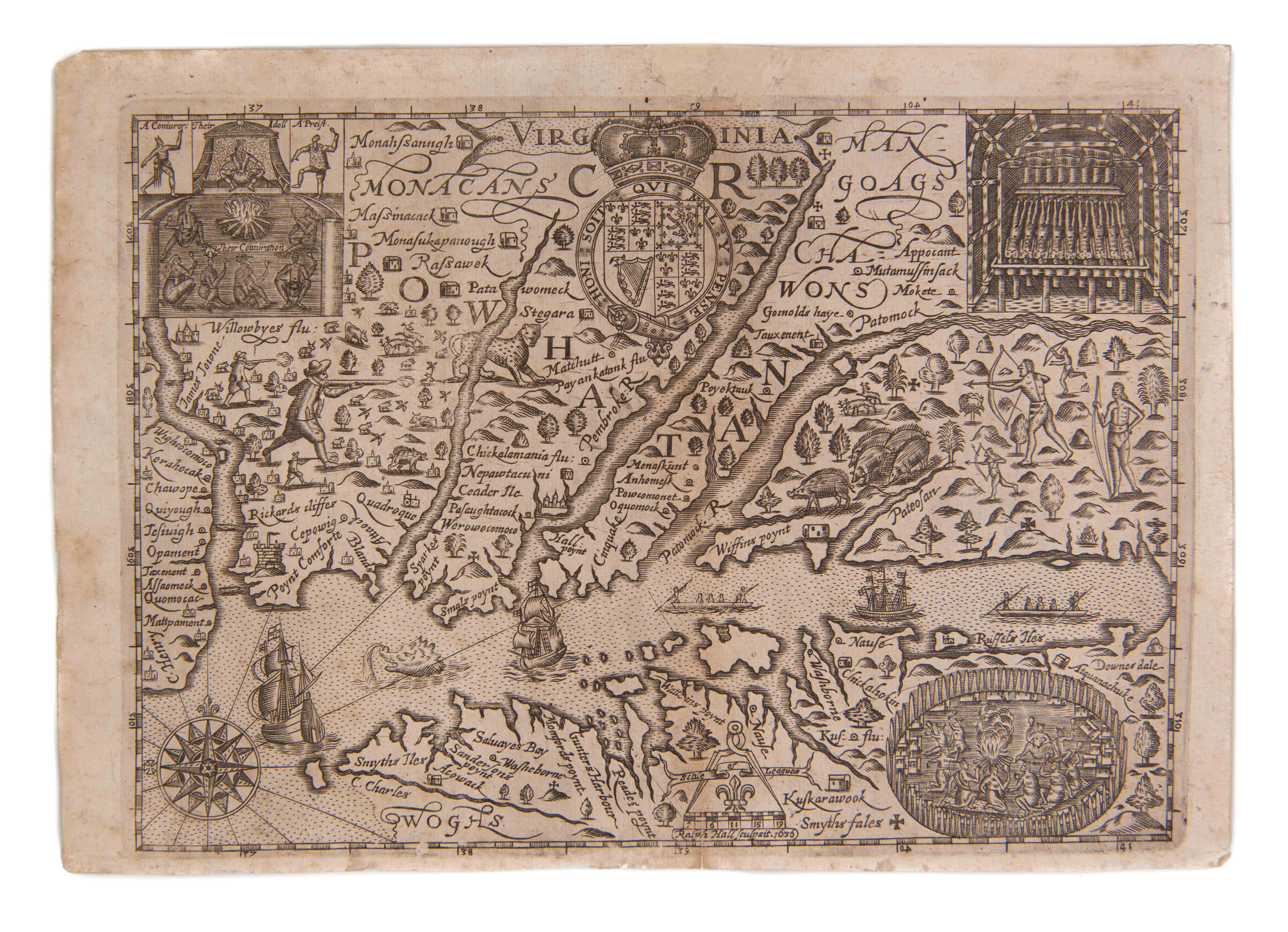
THE SECOND ENGLISH MAP OF THE VIRGINIA COLONY
Copper engraving measuring 170 by 240mm. Sympathetic repairs to top and lower margins, a little toned but very good. London, Michael Sparke & Samuel Cartwright, c.
This scarce map of Virginia was commissioned for inclusion in the first English language edition of the miniature Mercator atlas, published in London in 1635. However, and as often, the map took longer than expected to prepare and so the atlas was issued without it. At the time, the publishers noted that “In Page 905 for the Description of New Spaine read New Virginia, but there is no map of Virginia in regard where is a more exact Map drawing in that Country whose Platforme is not yet come over, but when it comes, every buyer of the Booke shall have it given him gratis.”
The map was based on Captain John Smith’s map of Virginia, which appeared just twelve years earlier in his Generall Historie of Virginia ... (London, 1624). So this connects the map to the foundation of the “New” Virginia colony at Jamestown, rather than Sir Walter Raleigh’s short-lived Virginia colony, established on Roanoke Island, North Carolina.
Hall’s map incorporates John White’s illustrations, which were actually made at the Roanoke Settlement. These images are instantly recognisable for being engraved by Theodore de Bry for Thomas Hariot’s A Briefe and True Report of the New Found Land of Virginia (1590). They are among the most important early illustrations of New World ethnography, fauna and flora. They include insets of a camp fire scene, Native priests, a charnel house and a village enclosed in a wooden palisade. Within the map itself are all manner of animals such as deer, pigs, a jaguar and a sea-monster, a European turret, and European and Native hunters. These images recurred for at least a generation. While the geographical information is the same as that in Smith’s it is not to be confused as a copy. Indeed, Hall even took the liberty of naming a promontory Hall’s Point after himself, and this remains its sole appearance.
Burden, Philip D., The Mapping of North America, p. 308, #244; Coolie, Verner, "The First Maps of Virginia" in 1590-1673" in The Virginia Magazine of History and Biography, Vol. 58, No.1 (Jan, 1950), pp.3-15; Stephenson, Richard W. and Marianne M. McKee, Virginia in Maps, pp. 13-14, 32, #I-7; Tooley, R. V. ed., The Mapping of North America, p. 167.
.
Stock Code: 223214


