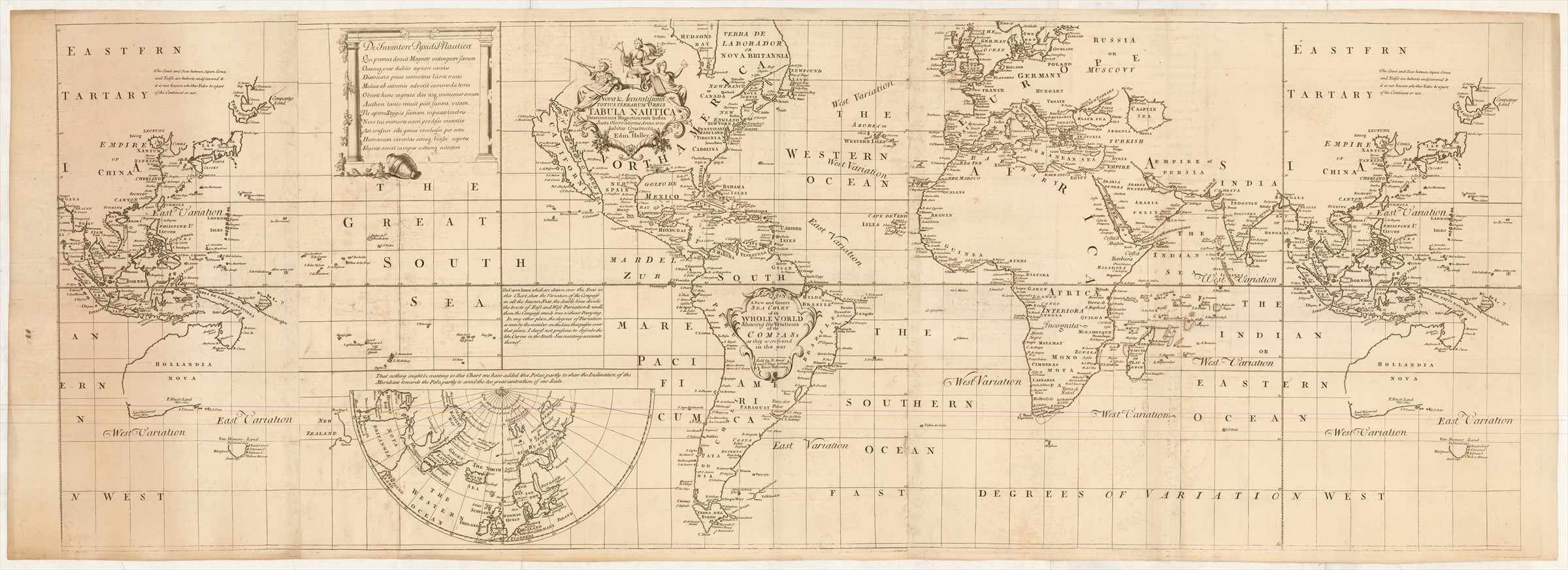
A New and Correct Sea Chart of the Whole World shewing the Variations of the Compass as they were found in the year [gap] … [second title:] Nova & Accuratissima Totius Terrarum Orbis Tabula Nautica Variationum Magneticarum Index Juxta Observationes Anno. 1700 habitas Constructa per Edm. Halley.
HALLEY Edmond ([ca. 1722].)
£25000.00
Please contact us in advance if you would like to view this book at our Curzon Street shop.
Copper engraving, widest: 518 x 1436 mm, on two sheets and half-sheets joined, the Australia/South-East Asia/Far East sheet present both at left and right. London, Mount & Page,
Halley's sea chart of the world is one of the most important scientific maps ever published, the application of a brilliant scientific mind to one of the basic problems of navigation, and producing the first published world magnetic chart. Various dates have been given for its first publication, but an announcement in the Post Man (issue 1354) for 7th - 9th December 1704 gives some indication of its first appearance.
This chart is printed from a set of replacement plates copied from the original set. The title bears the imprint of Richard Mount and Thomas Page, appropriate for the period 1700 to 1722 (the year of Richard Mount's death) but the omission of the ten line panegyric to Queen Anne (d. 1714) and dedication to Prince George of Denmark (d. 1708), her husband, points to a publication date post-1714. The positions of these two features are left blank (central Africa and central Asia). Furthermore, an exemplar printed from the first set of plates is dateable to [ca. 1718], which narrow the window still more.
The general appearance of the plates points to this printing being a preliminary proof before the insertion of the lines of the variation of the compass (the main purpose of the chart) and with a blank space in the English title where the date could be inserted. The absence of engraving where the original panegyric and dedication were located also suggests that these areas were yet to be completed.
The likelihood is that the first set of plates were damaged; the [ca. 1718] printing referred to above shows evidence of plate cracking; perhaps these second plates were commissioned as replacements but, for whatever reason were not completed at the time, perhaps because of the death of Richard Mount or (slightly later) Mount and Page's publication of Thomas Haselden's world chart, on a more convenient format, gave them a more suitable map for their purposes.
As sometimes found on the second state, this example has the additional half-sheet, covering Australia and the Pacific, correctly pasted-on at right but, additionally, also added along the left-hand border.
This is the only recorded example of this early (presumed proof) printing of the second plates.
From the Library of the Earls of Macclesfield, though not offered as part of the Sotheby's sales.
Stock Code: 226088


